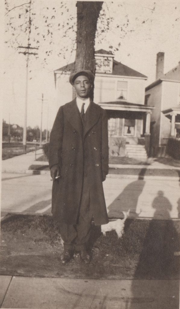
Dr. Albert B. Cleage Sr 
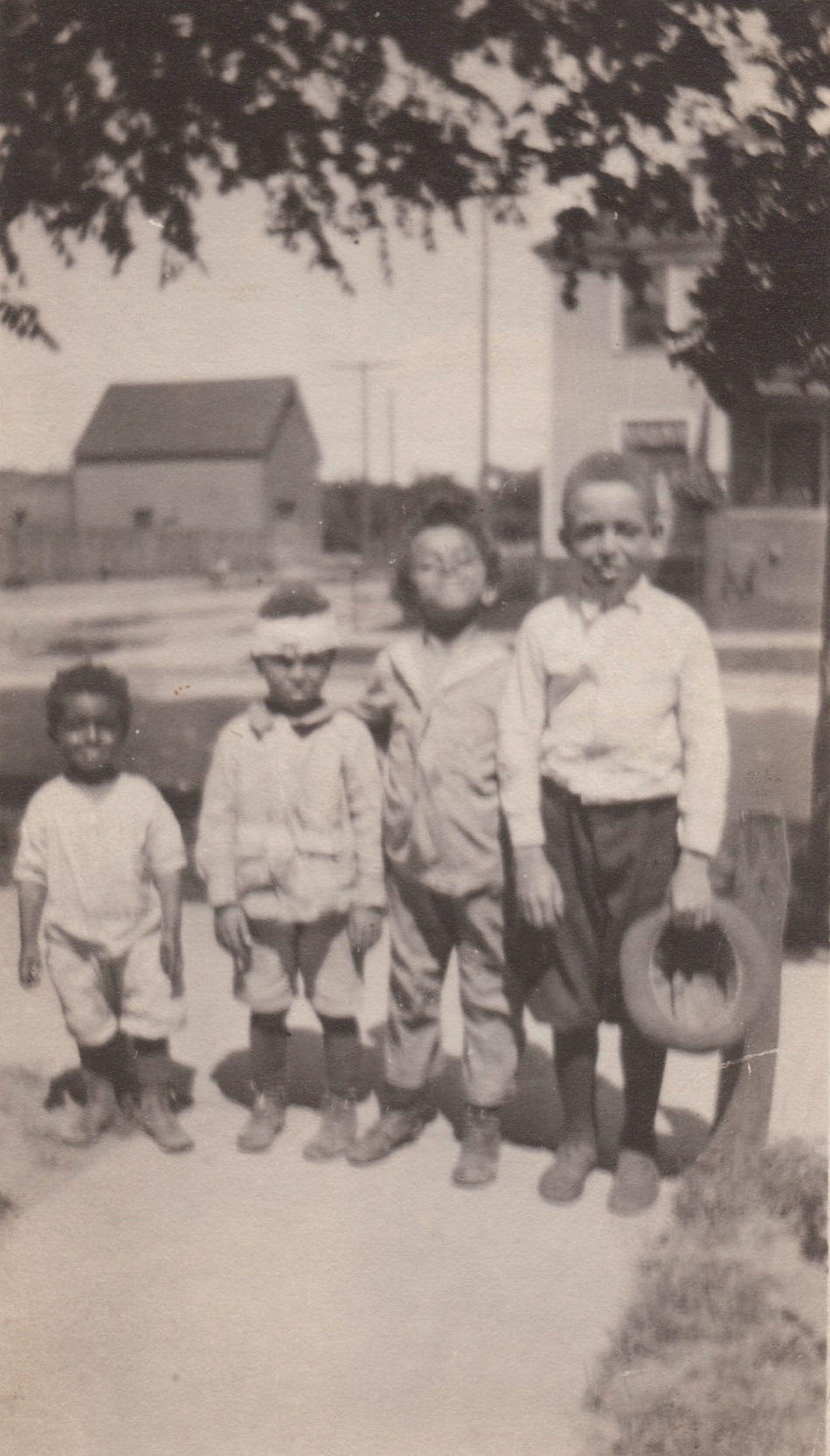
Hugh, Henry, Louis and Albert Jr 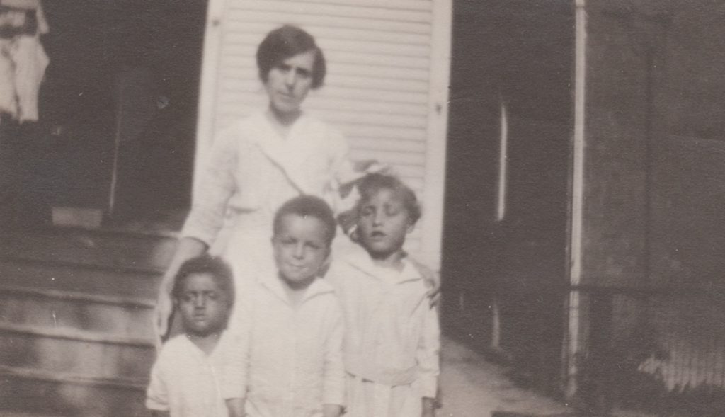
Pearl Cleage with Hugh, Henry and a neighbor.


The photographs used in this series are from my personal collection. Please do not use without my express permission.
I got carried away writing about where my Cleages lived in the 1920 census. The pictured houses below are from Google maps. There were many houses gone. The red line goes from the house picture to the map version. Some houses did not have numbers and I could only guess where they were on the block, so no line.
Inside the Sanborn map, I put the head of household, his or her occupation, how many people lived in the house and their race. This information is from the 1920 census. My grandparents and their sons lived in the house in the red yard. Unfortunately, that is now a vacant lot. You can tell the shape and size of the house from the diagrams. My grandparents house was two stories with a porch across the front of the house. There was no garage or other building in the backyard.
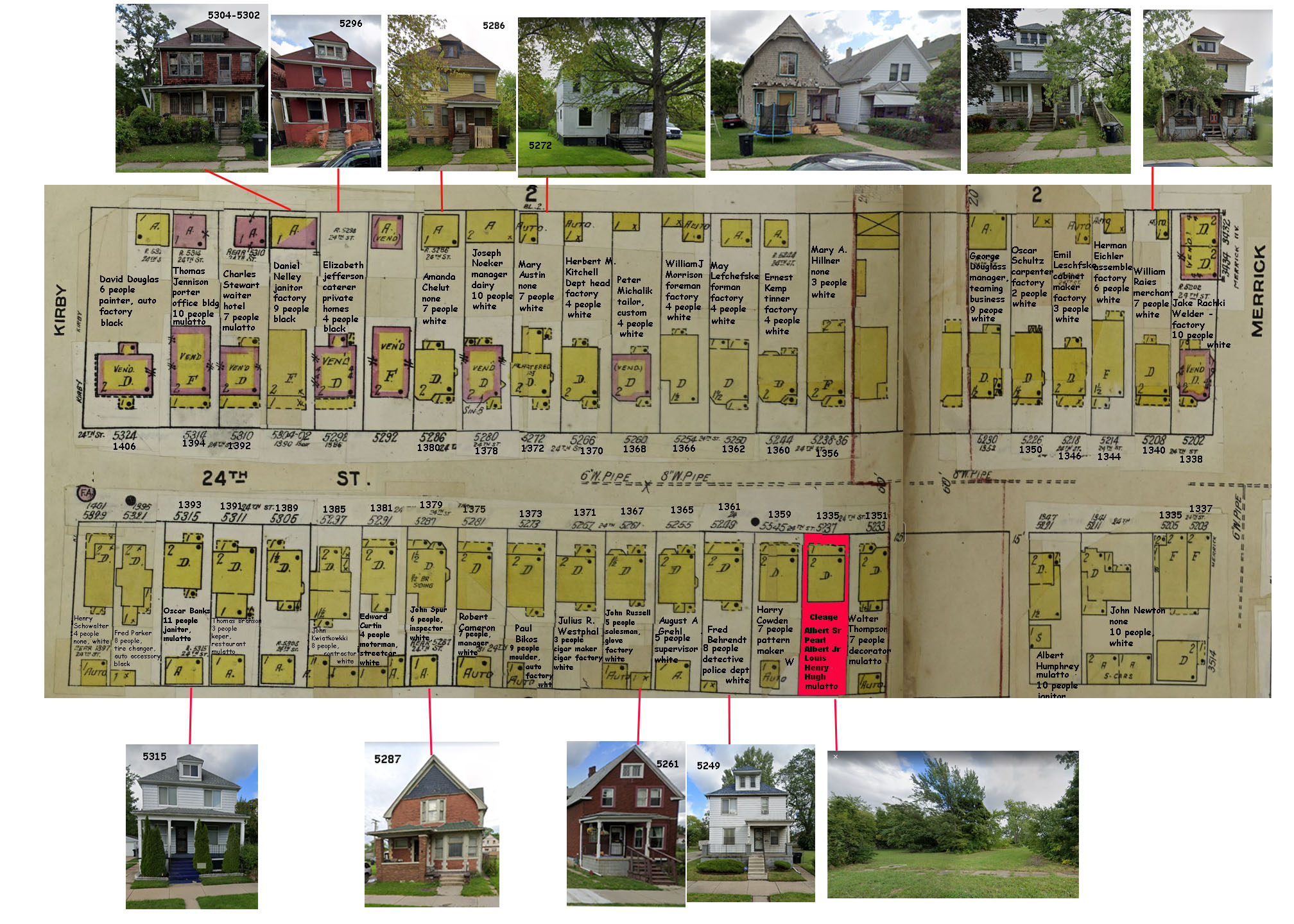
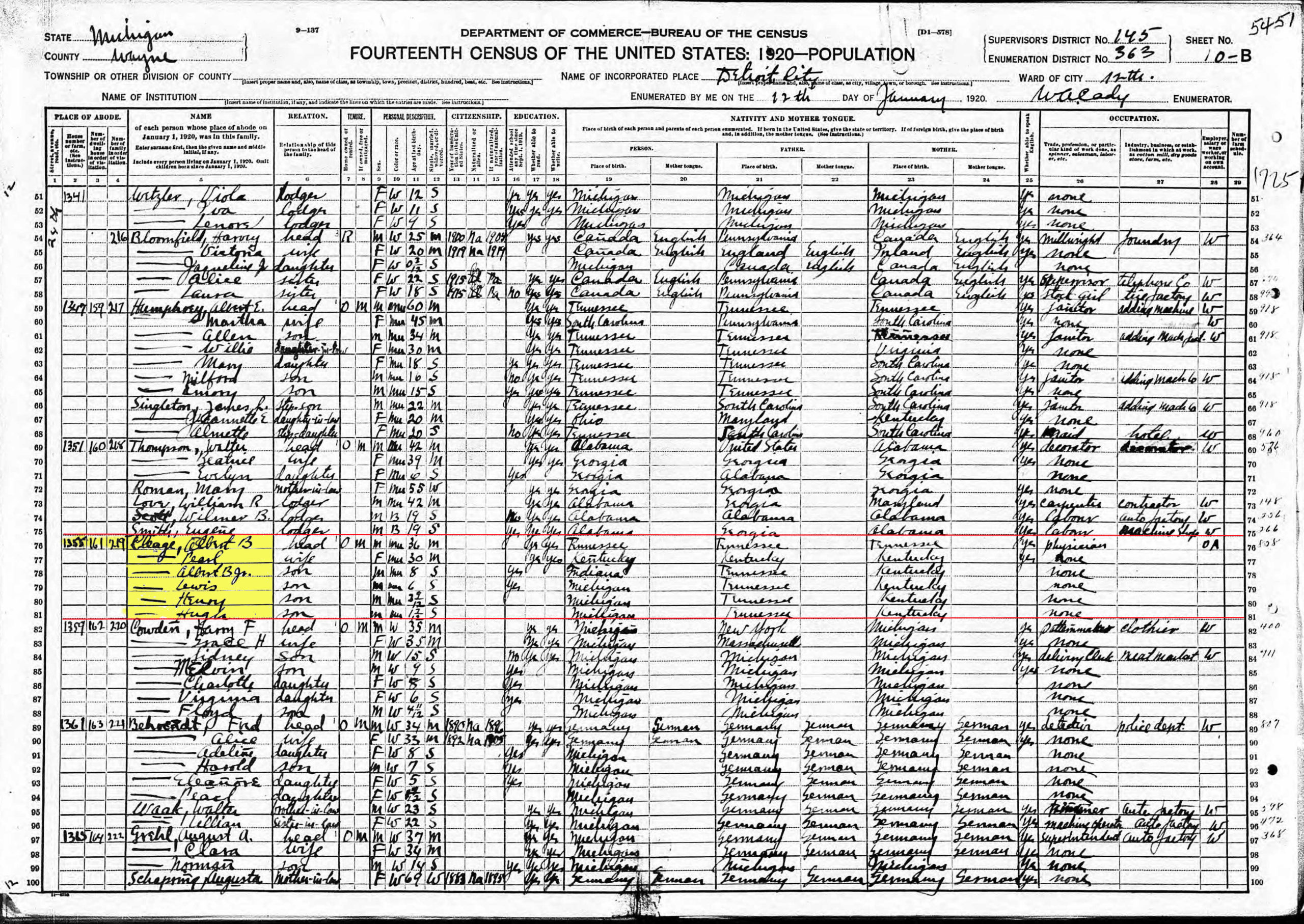
In the 1920 Census 36 year old Albert B. Cleage was a physician working on his own account. He was born in Tennessee, as were both of his parents. His wife, Pearl was listed as 30, although she was actually closer to 34. She and her parents were born in Kentucky. She and her husband were literate. Although this was not on the census form, she was about three months pregnant with Barbara her 5th child.
There were four sons in the household. My father, Albert was eight. Louis was six. Both of them attended Hubbard elementary school, which is now gone. Henry was three years and nine months old, Hugh was one year and seven months old.
They owned their home, which was mortgaged, at 1355 24th Street in Detroit. Later that year all of the street numbers were changed and the number became 5237 24th St. This caused me some trouble in years past, before I knew the numbers changed and had placed the house in the wrong place. To learn more, click. Detroit Citywide Address Change
Everybody in the family was identified as “mu”, which stood for “mulatto”. This was the last census to designate people as “mu(latto)” or “B(lack)”. In the 1930 census, “Neg(ro) would be used for both.

Discover more from Finding Eliza
Subscribe to get the latest posts sent to your email.
Absolutely fascinating.
What I love the most is that map with the photos of the houses. I love to see where people lived. And you must have done such an incredible work to present us this post.
I’m loving your challenge!
@JazzFeathers
The Old Shelter – Living the Twenties
Me too! I did spend a whole lot of time on the neighborhood and looking for the remaining houses. I was pretty disappointed that my grandparent’s home was gone. Not surprised though. My family homes tend to disappear.
Wow! That’s an incredible amount of research! I love it that Google Maps can be used for things like this…
I found the present day remaining houses on google maps. The old map with the houses is a Sanborn Map. They made maps of cities with all sorts of details. Sometimes they don’t have the neighborhoods I need, but this time they did.
Changing the numbers seems like a good way to confuse lots of people – glad you have it all figured out. I am always amazed at the detail you have dug up for everything.
Tasha 💖
Virginia’s Parlour – The Manor (Adult concepts – nothing explicit in posts)
Tasha’s Thinkings – Vampire Drabbles
As cities grew the old numbering systems got confusing and most cities decided to renumber everything. I confused people then and it confused me when I was trying to find houses. The same thing happened when I was looking for the Cleage house in Indianapolis – they changed the numbers several times there.
In awe of the work you’be put in to get all these details Kristin. Truly inspiring.
Thanks Arti. I really got a bit carried away here. 😀
As usual you blow me away with your research, Kristin!
I love how spaced out and green the neighbourhood looks.
It’s so spaced out and green because over half of the houses that used to be there are there no more. When my grandparents and their family lived there there were houses on almost every lot.
From a UK perspective, these houses all look so big. We are more used to rows of terraces, which were built in the Industrial Revolution to house the factory and railway workers… and then all the rest of us! I suppose there was just more space in the US, so they used it 🙂
You’ve done a huge amount of work, and all of it interesting.
They were big. Some cities did have row houses and in Detroit there were tenaments and crowded apartments the probably would have made the row houses look big.
I’m glad you are finding my posts interesting.
Very interesting! Did you include the other houses to give us neighborhood context or are they relatives?
I included the other houses to give neighborhood context. There were no other Cleage relatives in the area. The houses I included were the only ones left standing. The rest are now vacant lots. You know Detroit.
Wow, what a lot of information. I love maps, and imagining what it felt like to live in that neighborhood. It would be cool to have vintage photos of some of the houses to match with them, too.
Black and White (Words and Pictures)
I would have loved to find some old photographs of that neighborhood, but no such luck.
Wow, very impressed by the way you linked the Sanborn maps with photos of your ancestors’ homes. I also have situations where ancestral homes no longer stand, but it’s still possible to see the neighborhood. You should do a tutorial on how to do this…I would sign up!
Yes, looking at the neighborhood makes it possible to imagine the type of house it was even though it isn’t there.
A tutorial? I can’t imagine doing that. It was a lot of work and involved quite a bit of photoshoping photos and maps and typing in the information from various census sheets, looking at the 1920 Detroit City directory which has a all the old numbers along with the new numbers in the back.
Thanks so much for your recent visit to my blog and for your comment on my “A” post. It’s nice to meet you.
Census records are so interesting, aren’t they? You can learn so much. It’s funny how they used certain terminology (such as mulatto) that we now consider offensive. Like on 1880, there is a column designated “idiotic.”
Changing the addresses definitely makes for confusion. I have encountered that as well. Well, not so much as an address change, but a street being called by 2 different names.
Yes, I decided to go with what they had on the form, that being “mu(latto)” even though we never referred to ourselves as that ever.
It’s even worse when they change the street numbers and the street names, as happened in Indianapolis during the time I was looking for houses there.
The Sanborn map and aligned photos of houses are superb. I also like the little white dog in the picture of Dr Albert B. Cleage Snr. It looks a very nice neighbourhood with nice trees.
I knew that dogs name at one time. He appears later on in a family photo about 1929. He must have been pretty old by then. My grandfather had certainly aged during that time. It does look like a nice neighborhood. Later that year they moved further north to a larger house that will appear under “S” is for Scotten.
The passion you have for learning as much as you can about your ancestors shows. What a loving tribute to them.
I wish they were here to tell me about life in that house!
I agree with an earlier comment. you have done incredible material collection to present us this post. Great.
Coca-Cola – Cisco Systems – Industrial Engineering Activities and Jobs
Productivity Success Story of Coca Cola – CISCO Green Value Engineering
https://nraoiekc.blogspot.com/2020/04/coca-cola-cisco-systems-industrial.html
Thank you.
What a beautifully designed blog post, Kristin! And what a labor of love. Like everyone, I love and am amazed by the map with the house plots and occupants and the photos of houses or plots today. I linked to the newspaper site, and it looks like an interesting project too. I can see how genealogical research is endlessly fascinating; you can never get to the end of it.
That’s a lot of researches! Not fun when cities change their numbering, houses change a lot also with time.
C is for Colour
Yes they do change, but you can see the basic structure if you can find a photo of the surviving houses. It’s so sad that so many of the houses I want to see in Detroit are gone.
The maps are amazing…they’re the insurance ones aren’t they? You’ve done a determined and thorough job of sorting out the location.
Yes, they are the insurance maps. I got sort of sucked into this project and couldn’t get back out!
What runs through my mind is the writer Pearl Cleage. Is she kin to your family. This is all interesting. You do some good research. I enjoyed looking at the homes. Mu for mullato. I had a great uncle whose family was listed on a census as a mulatto. When I went back on that branch, I discovered he was a Lumbee Indian.
Yes, Pearl Cleage is my sister.
What fascinating records! It’s always sad when family homes are gone. The house where my mother mostly grew up in a little town of 400 people is gone, and it makes me sad on the rare occasion I have to go there.
My mother would never go over to the place where her old home was. She was very upset about it being gone.
I remember my father’s sister shaking her head because the people who bought the house cut down all the bushes around the porch. That wasn’t this house though, it was the one they moved to after this one.